
A copy of the powerpoint presentation that was given is available here - http://www.mtf.org.au/site/files/ul/dat ... 473575.ppt - inculdes a map showing the various changes, as beow.Melbourne Times Weekly wrote: Trams on track for change
BY REBECCA THISTLETON
YARRA Trams is investigating adjusting tram routes along St Kilda Road to improve capacity and tram priority.
The tram operator recently made a presentation to the Metropolitan Transport Forum revealing that Melbourne's trams spend almost 18 per cent of their time at traffic lights.
Public transport advocates applauded efforts to improve capacity by adjusting routes but said giving trams priority was the key to making them more efficient.
Yarra Trams' proposal suggested extending routes 64 and 74, which run along St Kilda Road and Swanston Street, beyond their terminus at Melbourne University to Moreland and East Coburg via Lygon Street.
New lines included a No. 11, to run from Victoria Harbour to West Preston via Collins Street, and a No. 12, from St Kilda to Hoddle Street via La Trobe Street.
Yarra Trams spokesman Colin Tyrus said the concept was presented to the Metropolitan Transport Forum to promote discussion about ways to enhance the efficiency of tram services along the St Kilda Road corridor while catering for the rapidly growing western end of the CBD and Docklands.
Mr Tyrus said the map did not indicate government policy and any network changes would be determined by the government.
Public Transport Users Association president Daniel Bowen said route realignments would increase the number of people moving along St Kilda Road and towards Southern Cross Station and Docklands.
He said efforts would be effective if trams gained greater road priority and spent less time at red lights.
Professor Graham Currie, who heads the Monash University Public Transport Research Group, said tram route changes were a good idea but costly to implement.
"Trams are more popular with the public than buses. However, trams cost a lot more when you look at changing where they go."
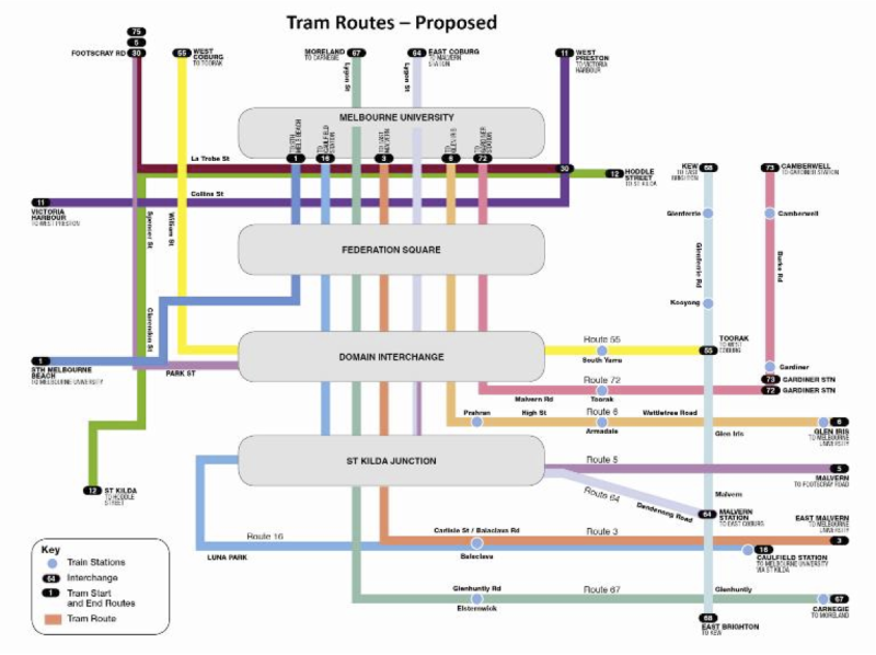
Robert Amos wrote this excellent summary to TramNews newsgroup of the key changes, I've made a few changes.
- Route 1 terminates at Melbourne Uni not East Coburg.
- Route 3 no change (3A not shown)
- Route 5 runs along Park St from Domain Interchange, into Clarendon and Spencer to terminate at Footscray Road
- Route 6 no change
- Route 8 removed. Route 55 extended along Toorak Road to existing Route 8 terminus. Route 67 extended to Moreland.
- Route 11 established as full route West Preston to Victoria Harbour.
- Route 12 from Hoddle St/Victoria Pde to the existing Route 112 terminus at Fitzroy St, St Kilda. Runs via La Trobe Street, providing full time service on this corridor at last
- Route 16 shortened to run from Melb Uni to Caulfield Station. Route 58 (I think?) does Glenferrie/Hawthorn Rd from Kew to East Brighton
- Route 30 extended to Footscray Rd
- Route 55 extended along Toorak Rd to Glenferrie Rd (replacing southern end of Route 8 )
- Route 58 (?) created to run along Glenferrie/Hawthorn Rds from Kew to East Brighton.
- Route 64 terminates at Malvern Station. Extended beyond Melb Uni to East Coburg (replacing northern end of Route 1). 58 replaces southern end.
- Route 67 extended beyond Melb Uni to Moreland (replacing northern end of Route 8 )
- Route 72 terminates at Gardiner Station.
- Route 73 created to run from Gardiner Station along Burke Rd to Cotham Rd (Camberwell end of Route 72)
- Route 75 extended to Footscray Rd
I much prefer it than TransDev's suggestion a few years ago of connecting shuttles along St Kilda Rd. (as detailed in this leaflet - http://www.yarratrams.com.au/Portaldata ... _Road_.pdf)
Kind Regards
Craig


